Why Namibia?
The whole reason you wanted to come to Namibia in the first place, without worrying about logistics and details.
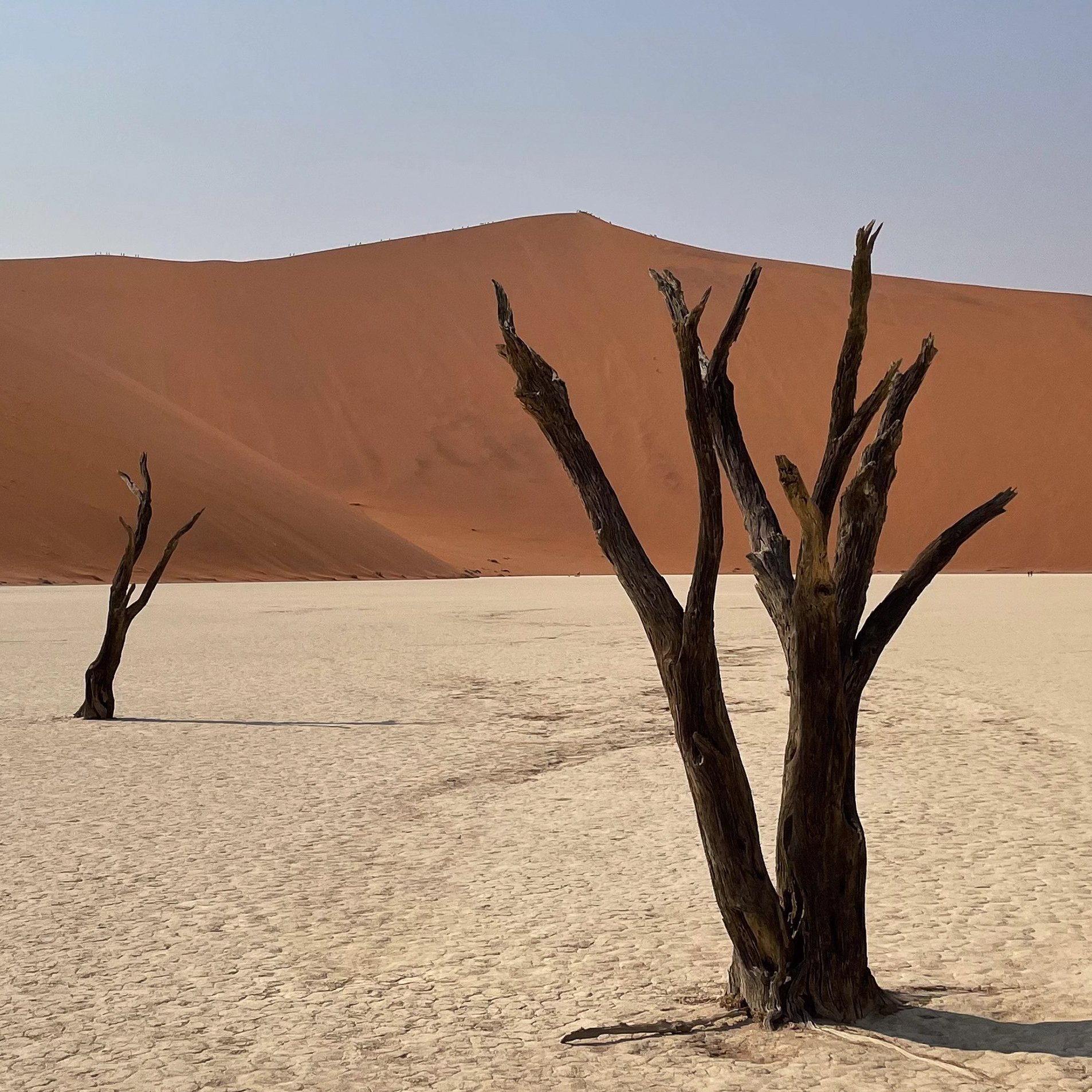
You’ve always dreamed of standing at Deadvlei, taking in the contrast between the bright orange sand and the baked white clay of the pan, whilst drinking in the solitude and serenity of the Namib desert


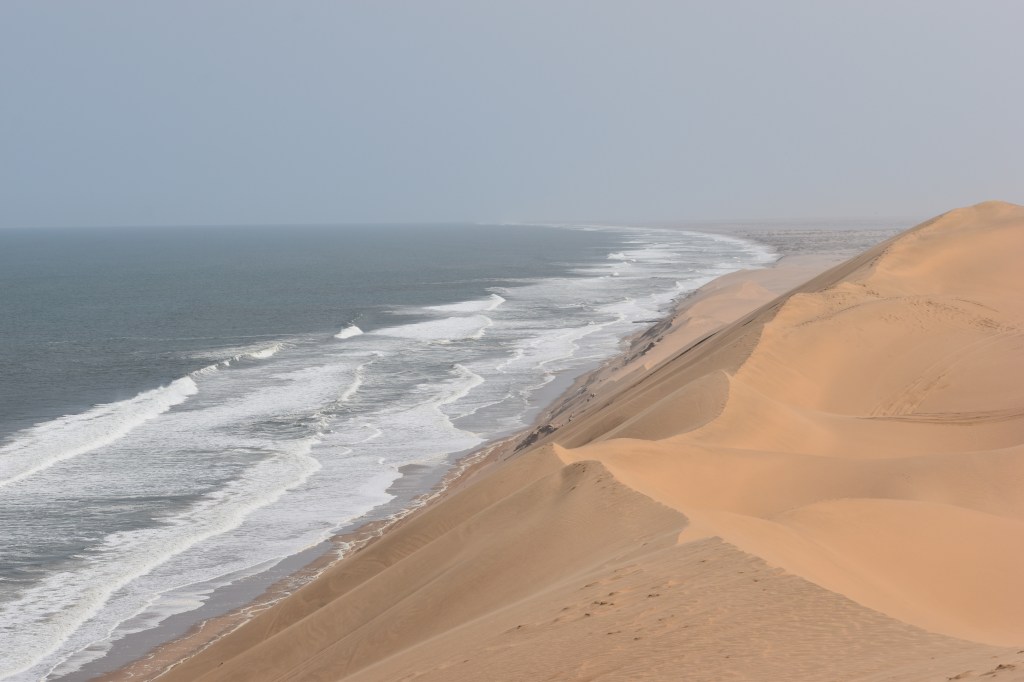
Or maybe it’s the dunes meeting the ocean at Sandwich Harbour, experience the thrill of careening up and down the dunes in a 4×4, and wathcing the flamingos and pelicans as they stand together in their little oasis


Feel the chill of the wild and cold south Atlantic ocean crashing on to the desolate skeleton coast and you travel northward for 100s of kilometers without seeing another soul
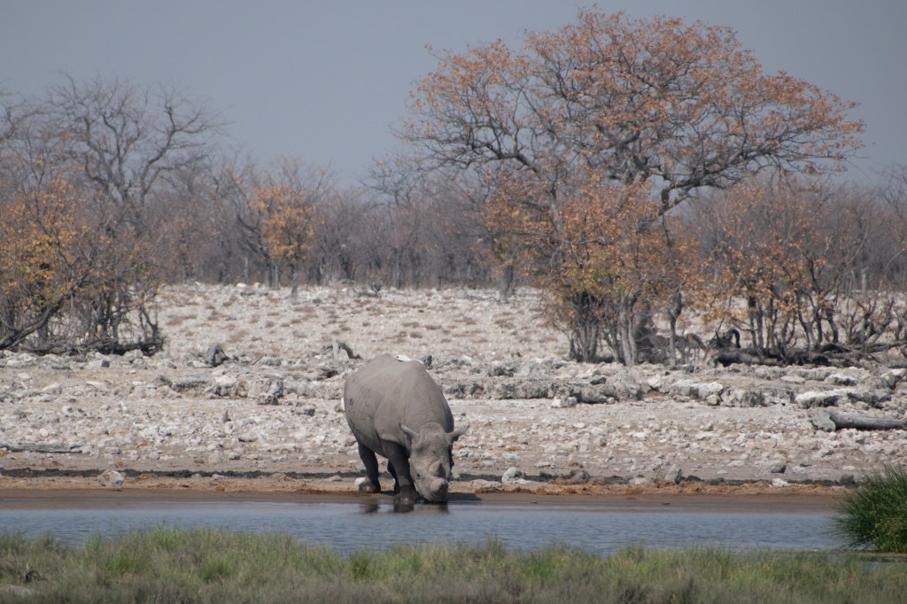
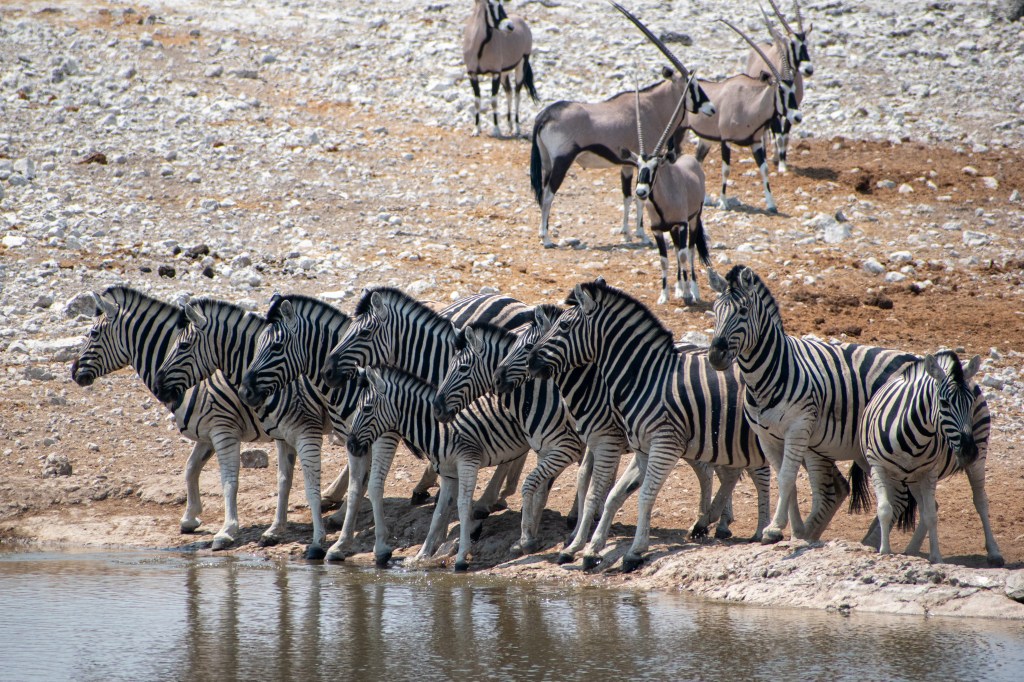
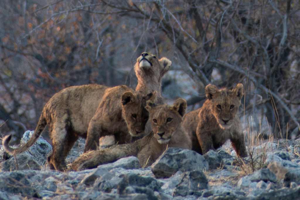
Spend days getting lost around Etosha, one of the world’s truly unique national parks, unparalleled wildlife, and the best possible destination for a self-drive safari
Our Route – Details
We are by no means an authority on the optimum route – but let me share ours as a starting point
We covered 4,506km over 18 days and would do it again in a heartbeat, but here are some things we learned along the way.
Making a plan
To start with, you need an idea of where you want to visit. Namibia had the allure of having an array of different places and activities. Doing the same thing for two weeks is the antithesis of an adventure. In Namibia there are dunes to climb, coast to visit and wildlife to spot, which provides enough variety for a year of travel, let alone 18 days.
When you look at a satellite image of Southern Africa, a number of large geographical features immediately stand out. Our challenge was how to visit them.

The Kalahari Desert dominates the area straddling the Namibia/Botswana border. It is a huge basin of sand, and whilst it’s known as a dry and hot desert, that’s not strictly true. The area does receive significant rainfall in the summer months (November-February) and is transformed briefly into a green paradise with abundant food. The Winter is cold and dry, temperatures frequently drop below zero and the vegetation dies back. As the heat builds in October before the rains arrive the Kalahari is a hostile place to be.
The Namib desert is different. It is often confused and conflated with the Kalahari, but is in fact very different. Here is one of the driest places on the planet, and is known as the world’s oldest desert. The formation of the desert is aided by the cold Benguela current off the coast of Namibia. The cold air can only hold limited moisture, resulting in fogs forming along the coastline providing a vital water source. However the heat of the interior prevents any moisture moving inland. At Walvis Bay the weather is often cold and foggy, yet 50km in-land it can be as hot and dry as it comes.
Skeleton Coast is the northern extension of the Namib desert, here the rolling dunes have given way to a barren, rocky, featureless landscape. Littered with shipwrecks and seals, there is little else to see out here other than the barren and empty land.
Etosha National Park is famous the world over for it’s abundance of wildlife. The main visible feature is the enormous salt pan accounting for over half of the park’s area.
The Okavango Delta has a deserved reputation for being the premier wildlife viewing destination on the planet. Millions of litres of flood waters flow down from the Angolan highlands. Arriving from May, the landscape is transformed into a wildlife haven. Formed by geological faults slowing the Okavango river’s journey across the plains of the northern Kalahari. The resulting loss of energy after Popa Falls in Namibia, causes the river to fan out across the plains forming lakes and lagoons across the landscape. What’s left of the water as it reaches the end of the delta is swept up by the Thakalamane which flows in a geological fault through Maun. Waters arrive here much later in the year and the flow moves incredibly slowly. In years of good floods the water continues southwards from Maun. The Boteti river can be filled all the way to the Makgadikgadi Pans and the famed Zebra migration can be seen in all its glory.
Namibia and Botswana – route tips
Windhoek to Sesriem to Sossusvlei
Google Maps will tell you this is just over a 4 hour drive, it will take you 5.5 hours or more. Welcome to the first rule of driving in Namibia.
There are a few route options, we opted to use the Spreeshoogte Pass route. In September the weather is good and the roads are in good condition. In the Summer months it may be wiser to go via Rehoboth.
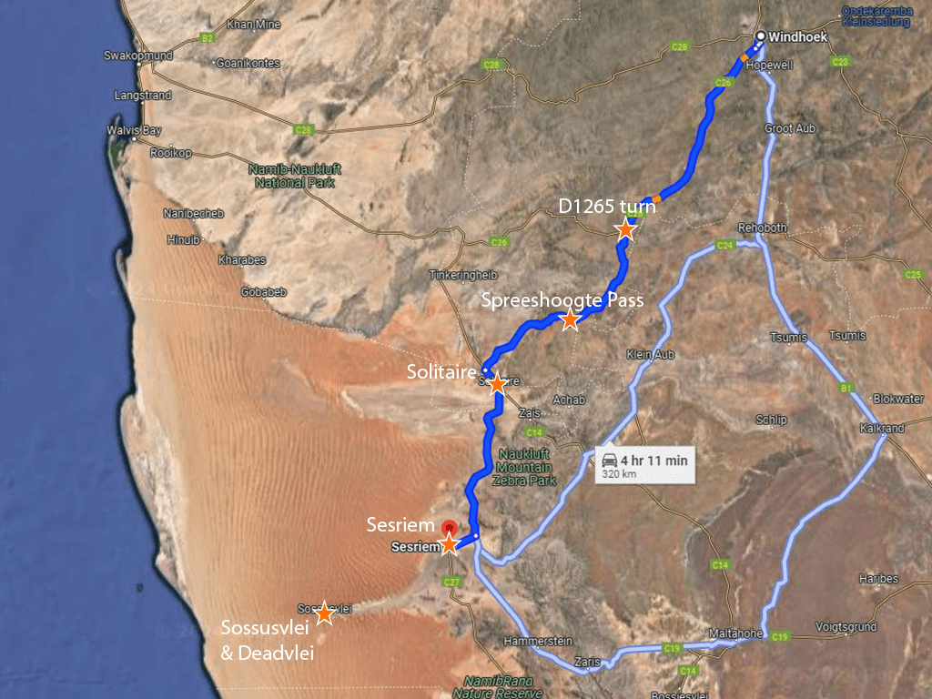
Roughly 10km or so outside of Windhoek, the road turns to gravel. It is gravel all the way to Sesriem, save for the block-paved route down the Spreeshoogte pass. There are only a few turnings you need to make. Turn left onto the D1265 roughly 1.5 hours out of Windhoek. Shortly after this turn there is a tropic of Capricorn sign you may stop at which is less busy than the one on the Walvis Bay route.
Speedlimits on gravel roads
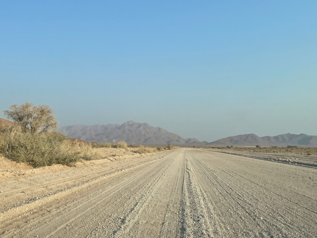
- The speed limit on the gravel roads is in most sections 100km/h.
- Your car rental agreement will likely forbid you from driving over 80km/h.
- In many places the appropriate speed is 60km/h or less.
- Drive carefully, and leave yourself plenty of time.
The second turn is a right hand turn at Nauchas. Spreeshoogte pass has a nice panorama over the desert below. Keep an eye on the time, it’s just under 2 hours to Sesriem from here. If you’re staying inside the National Park be sure to arrive before the outer gates close shortly after sunset, for more information see the NWR website
Once you reach Solitaire there is fuel and a nice bakery. From here it’s an hour to Sesriem. The gravel road quality changes with the seasons and the maintenance schedule, when we travelled in September 2023 this was the worst section, but as always your experience may vary.
There is a final right hand turn you need to make 12km before Sesriem. You can’t miss it as it’s a beautiful new tarred road which leads all the way to the National Park entrance.
Sesriem to Solitaire is an extra hour’s drive. The road is a great new tarred road all the way to the main parking area. However, the speed limit is 60km/h in the park, and you must be sure to stick to it.
At the main car park you have the option of leaving your vehicle and taking a shuttle bus to Deadvlei, or you can continue along the road. It’s only a few more km to Deadvlei.
Beware the road after this point becomes deep sand, and you may find yourself getting stuck. You will need a 4×4 and you will need know a bit about driving on sand. Change your tyre pressures, and possibly use low range. If you’re not sure what this means, then look it up.
This is perhaps a safe place to practice your sand driving, it’s busy and we saw others get stuck. Better to get experience recovering your vehicle here than somewhere more remote.

Sossusvlei to Swakopmund
Retrace your way back to Solitaire and stop for a slice of apple pie. From Sossusvlei this is 2 hours, from Sesriem just the one.
The route to Swakopmund is well signposted, so there’s no need for snazzy maps or GIFs. But this is a longer drive than you may have anticipated.
It is 3.5 to 4 hours from Solitaire to Swakopmund, you must leave whilst the sun is still high in the air and sunset feels a distant future.
At Walvis Bay there is a huge roundabout and an even bigger mall – a good place for provisions should you be running low.
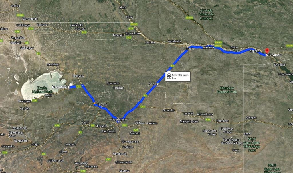
Etosha to Divundu
How far can you get from Namutoni camp? I’m not the only person ever to ask this.
This was the day we thought would cause the most problems, it is a long drive, and our research seemed to advise against it.
However the roads between Namutoni camp and Divundu were in great condition, so we really didn’t need the extra time we had budgeted in our plan
North of Mururani vet fence everything changes – in a good way, this feels more like Africa, however there are animals and people on the road now so drive considerately.
Popa Falls to Kongola is 2.5 hours, and it is long. Do not attempt to reach the Kwando river from Etosha in a day, you won’t make it.
It took us a whole day on the road, but we made it to Popa Falls by sunset.
Here’s some timing details:
I was anxious about timings – so over prepared accordingly! – so much so that I made a spreadsheet with estimated timings which is available here
The short answer is it took us all day, including stops, and we arrived in time for sunset. (left Etosha at 8:55 and arrived at our campsite at 18:10)
There are good quality tar roads all the way from Namutoni camp to Divundu. (which, after Damaraland and Etosha were certainly not a given!).
In more detail: (including timestamps from my camera roll)
6:55 – We left when the Namutoni gates opened
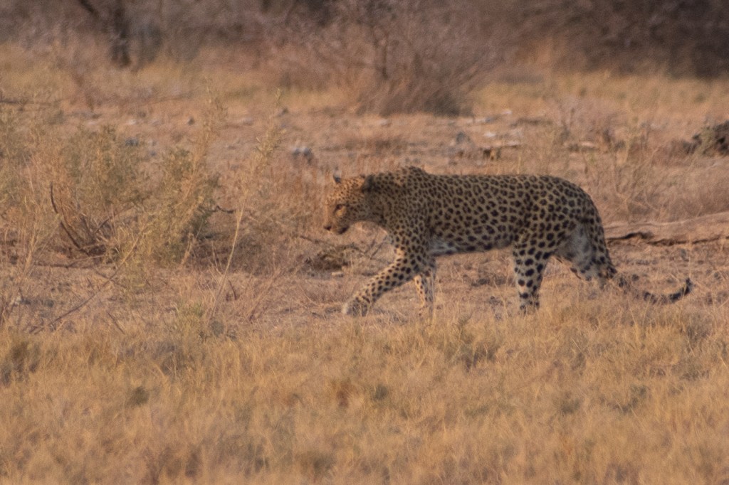
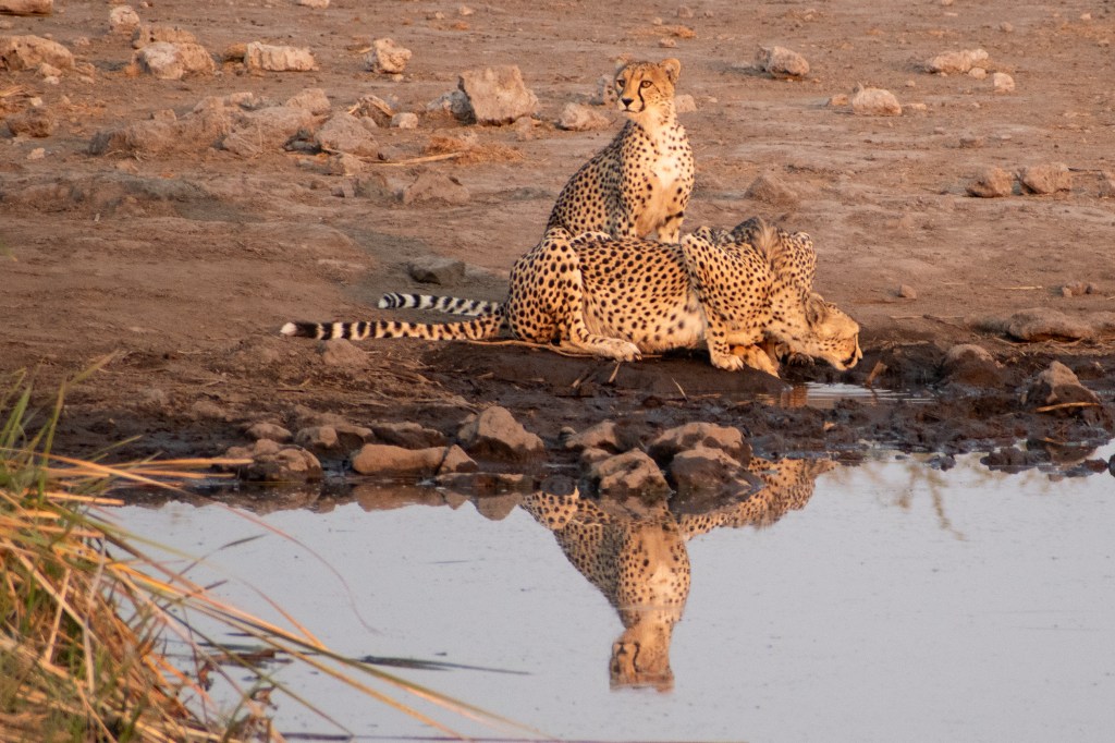
We had a bit of a last morning game drive and got pretty lucky. 3 Cheetahs at Koinachas at 7:20, and a Leopard on the airstrip at 7:45, and a final good sighting on the way to Groot Okevi.
8:40 We were back in camp for a toilet break.
8:55 – We did not exit Von Lindequist gate until 8:55. (at this point google maps gave us an arrival time of 15:27 (6.5 hours for 630km) – note: google maps times are not achievable)
–
(1:50 drive)
–
10:45 – arrived at the butchers in Grootfontein, spent 1 hour stocking up on supplies at clicks, pick and pay, etc.
11:45 – departed the pick and pay
–
(1:05 drive)
–
12:50 – stopped for a tea/coffee at Roy’s Rest Camp
–
(2:05 drive – including vet fence)
–
15:15 – fuel stop at Rundu (we had eaten lunch on the road, and had ice creams from the shell petrol station)
15:40 – after a detour through Rundu, we have a photo of us on the outskirts of Rundu heading east.
–
(2:25 drive – including waiting at roadworks)
–
18:10 – photo of our vehicle at our campsite at Divundu (note: NOT Ngepi, you might need to allow another 20-30 mins)
18:30 – sunset.TOTAL DRIVING 7:25
Total stops – 1hr grocery shopping Grootfontein, 20-30 mins tea break at Roy’s, 20 mins refuel in Rundu. Etosha exit gate and Mururani Vet fence were less than 5 mins
How to drive to Savuti
Driving across Chobe National Park between Maun and Kasane via Savuti is a great adventure and one that attracts many wildlife and 4×4 enthusiasts. It’s a trip that’s certainly practical if you prepare well and take the right precautions.
We traversed the park from North to South over two days. The trip from Ngoma to Savuti is roughly 4-5 hours. From Savuti to Mababe or Khwai is slightly longer at perhaps 5 hours. All of this depends on the road conditions, the route taken, the time-of-year, and how long you spend spotting wildlife.
For details of our journey read our blog post
Windhoek to Maun is a long long way
Due to planning our trip at the last minute we first secured flights into Windhoek, and then secured a rental vehicle from Windhoek. After we had those basics covered we were free to decide on a route (which at this point had to be a circuit)
If we were to travel the same route again we’d organise a one-way drop at Maun, and fly back to Johannesburg from their, it would save us money on the rental overall, but you are subject to flight schedules and prices (return tickets being a bit cheaper than one-way fares)
But seriously… Maun to Windhoek took us 10.5 hours driving, and there is very little of interest along the way… we had a couple of splashes of rain on the windscreen about 1 hour before reaching Gobabis, that was the most memorable thing. Oh and a toastie that took 40 minutes to prepare at the East Gate cafe on Namibian side of the border.
Getting the timings right
One of the exercises we did before travelling was to analyse our drive times – it was most useful to identify potential issues earlier on in the day.
For example, when driving from Sossusvlei to Swakopmund we budgeted 5:45 driving time and 1 hour for breaks. We were at McGregor’s bakery in Solitaire at 14:45 enjoying our cup of tea and apple pie.
However, knowing that sunset was 18:45 in Swakopmund and that there was 3:45 driving remaining in the day we were already tight for time.
It didn’t feel like it – the sun was high in the sky and weather was hot, but if we didn’t leave soon we could get into trouble. We had to down our tea and we would have to keep any further rest breaks to a minimum.
We arrived at our accommodation in Swakopmund 15 minutes after sunset and to some quite worrried SMS messages trying to locate us!
It if fairly crucial to arrive at your destination prior to sunset for a number of reasons
- The vehicle hire agencies tend not to insure you for driving in the dark on the routes between towns
- Animals on the roads are at best hazard during the day, at night they can cause terrible accidents, if driving at night you must drive slowly and with great caution
- Setting up camp is much more efficient with some daylight left
The sun sets quickly in Namibia – they don’t get an extended twilight like we do in the UK, it is dark within 30 minutes of sunset. Do plan ahead.
